Introduction
Char Dham Yatra is a popular pilgrimage in India and is deeply rooted in Hinduism. This pilgrimage circuit includes four sacred shrines in different districts of Uttarakhand, India. Millions of pilgrims and travellers visit these temples to seek blessings and cleanse sins. But the major problem during the journey is knowing the correct Char Dham Yatra route map. All the temples are located in the Inner Himalaya, so locating these temples is really tough.
To address this problem, we are going to brief you about the Char Dham route map with distance. Whether you are travelling from Delhi, Dehradun, Haridwar, or any major city, this blog is going to help you a lot in planning your yatra.
About Char Dham Temples
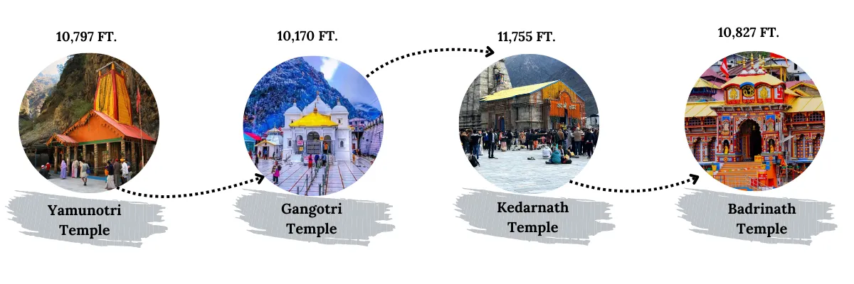
The sacred Char Dham yatra is a pilgrimage which includes the four holy shrines named Yamunotri , Gangotri , Kedarnath , and Badrinath . All four shrines are situated in different districts of the Garhwal region in Uttarakhand, offering stunning views of nature. Each shrine is dedicated to a specific god with spiritual significance and mythology behind it, which holds deep faith among the pilgrims visiting the Char Dham Temples.
The four holy shrines of Char Dham yatra are:
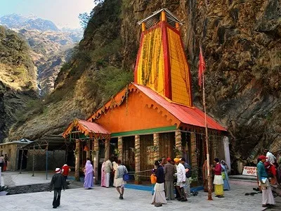
Yamunotri
Yamunotri Temple is the first temple among the four shrines of Char Dham Yatra, dedicated to Goddess Yamuna, located in the Garhwal region of Uttarkashi district in Uttarakhand, India, at an elevation of 3,291m (10,797 ft) above sea level. It is located at the origin of the river Yamuna.
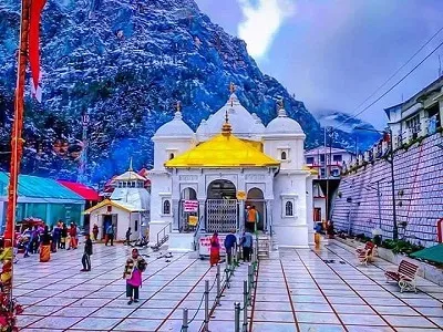
Gangotri
Gangotri Temple is located in the Uttarkashi district in the Garhwal region of Uttarakhand at an altitude of 3,100m (10,170 ft) above sea level. This is the second destination among the four temples of the Char Dham circuit, dedicated to Goddess Ganga. It is located on the bank of the Bhagirathi River, the major tributary of the river Ganga.
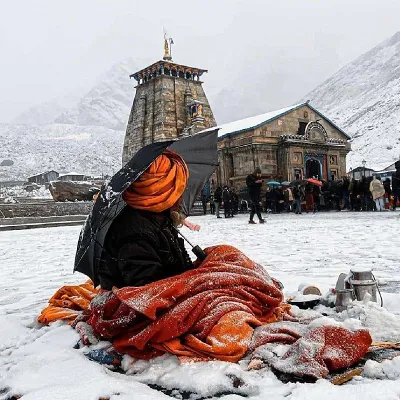
Kedarnath
Kedarnath Temple is the third holy shrine of this pilgrimage circuit, dedicated to Lord Shiva and part of Panch Kedar , and the 12 jyotirling , well-known for its spiritual and divine energy. Located in the Rudraprayag district of Uttarakhand at an altitude of 3,583m (11,755 ft) above sea level considered the highest among all the temples in this circuit.
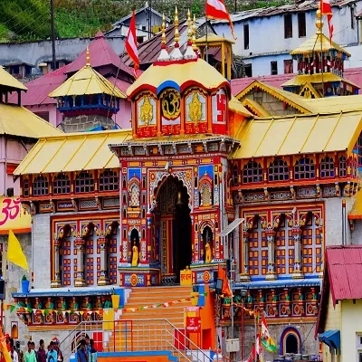
Badrinath
Badrinath Temple is the last shrine among the Do Dham and Char Dham Yatra, dedicated to Lord Vishnu. It is an integral part of the 108 Divya desam, Sapt Badri and Panch Badri temples . The temple is located in the Chamoli district of Uttarakhand, situated at an elevation of 3,300m (10,827 ft) above sea level, surrounded by the Nar-Narayan mountain ranges.
Temple Order: Char Dham Route
Char Dham Yatra comprises four shrines. Together, they are known as the Chota Char Dham Yatra. The standard Chota Char Dham Yatra route followed by the pilgrims starts from Yamunotri and ends at Badrinath.
Route: Yamunotri → Gangotri → Kedarnath → Badrinath
Reason for the standard order of Char Dham Temples:
-
Religious Significance: It is considered that the journey from Yamunotri to Badrinath signifies the progress from purification ( Yamunotri Dham ) to salvation at Badrinath Dham .
-
Geographical Alignment: The Uttarakhand Char Dham Yatra Route Map runs from the west to the east, then gradually moves northward into the higher Himalayas.
-
Travel Convenience: This standard order of the Char Dham Yatra Road Route Map minimises the backtracking and reduces travel fatigue and exertion.
Char Dham Yatra Route Map
The Char Dham route plan depends on the places from where you start your journey. In this comprehensive route map of the Char Dham Yatra, we are guiding you on all the possible routes from major places chosen by most pilgrims.
The major starting points for Char Dham Yatra are–
Haridwar | Rishikesh | Dehradun
Haridwar Route Map: Haridwar → Rishikesh → Barkot → Yamunotri → Barkot → Uttarkashi → Gangotri → Uttarkashi → Guptkashi → Gaurikund → Kedarnath → Gaurikund → Guptkashi → Rudraprayag → Joshimath → Badrinath →Joshimath → Rudraprayag → Haridwar
Rishikesh Route Map:
Rishikesh
→
Barkot → Yamunotri → Barkot → Uttarkashi → Gangotri → Uttarkashi→ Guptkashi → Gaurikund → Kedarnath → Gaurikund → Guptkashi → Rudraprayag →Joshimath → Badrinath →Joshimath →
Rudraprayag
→ Rishikesh
Dehradun Route Map: Dehradun → Barkot → Yamunotri → Barkot → Uttarkashi → Gangotri → Uttarkashi→ Guptkashi → Gaurikund → Kedarnath → Gaurikund → Guptkashi → Rudraprayag →Joshimath → Badrinath →Joshimath → Rudraprayag → Rishikesh → Dehradun
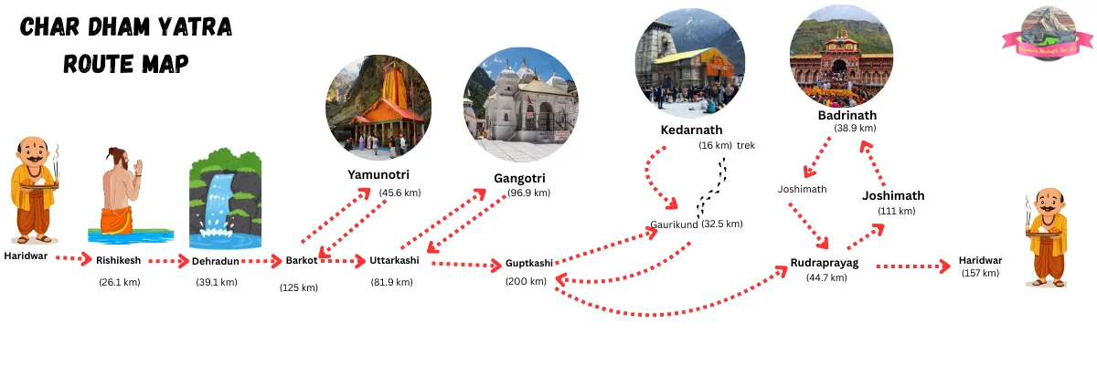
These three are the most common points from where pilgrims and visitors of Char Dham Yatra choose to begin their journey. These places offer many facilities, and the road condition offers a comfortable journey.
Jolly Grant Airport in Dehradun is the nearest airport to the Char Dham, and Haridwar and Rishikesh are the nearest railheads. Also, these are the connecting places for the Char Dham route from major cities, including Delhi, Mumbai, Patna, and more.
Char Dham Yatra Distance From Starting Points
The accurate distance chart of the Char Dham route from Haridwar, Rishikesh, and Dehradun, the major starting points chosen by the pilgrims to begin their journey of salvation.
Char Dham Yatra Route: Flow Chart
This is the Char Dham route map, starting from Haridwar or Rishikesh to the final destination, Badrinath Dham, while covering the other shrines of Char Dham, including Yamunotri, Gangotri, and Kedarnath.
4 Dham Yatra route map from the most preferred location to begin the journey of salvation, Char Dham Yatra route from Haridwar, and Rishikesh.
Route: Haridwar → Rishikesh → Barkot → Yamunotri → Uttarkashi → Gangotri → Guptkashi → Gaurikund → Kedarnath → Joshimath → Badrinath
Yamunotri Route Map
Haridwar to Yamunotri Distance : 221 kilometres
Time Taken: 7 to 8 hours drive + Trek
Trek Distance: 6 to 7 km
Trek Time: 3 to 4 hrs
Altitude: 3,293 meters (10,804 feet)
Route: Haridwar → Rishikesh → Barkot → Janki Chatti → Yamunotri
Tip: Roads are motorable till Janki chatti, but can be slippery during the monsoon. Daytime travel is recommended.
Gangotri Route Map
The Gangotri Temple is situated in the Uttarkashi district in the Garhwal region of Uttarakhand. Gangotri Dham is considered the second of the four sacred shrines of the Char Dham pilgrimage circuit, the origin of the holy river Ganga. This shrine is easily accessible by road journey.
Yamunotri to Gangotri Distance: 221 kilometres
Time Taken: 6 to 7 hours
Altitude: 3,100 meters (10,170 feet)
Route: Yamunotri → Barkot → Uttarkashi → Harsil → Gangotri
Tip: Roads offer scenic views. High landslide risk during the monsoon.
Kedarnath Route Map
The highest temple among the Char Dham shrines is the third one, named Kedarnath, located in the Garhwal region of Rudraprayag district of Uttarakhand.
The
The Kedarnath route map involves a road journey from Gangotri to Gaurikund. The total road journey is 326 Kms with a short trek of 16 km, which starts from Gaurikund.
Gangotri to Kedarnath Distance: 326 km + 16 km trek
Time Taken: 11 to 12 hrs + trek
Trek Distance: 16 km Kedarnath trek
Trek Time: 7 to 10 hrs
Altitude: 3,583 meters (11,755 feet)
Route: Gangotri → Uttarkashi → Rudraprayag → Guptkashi → Sonprayag → Gaurikund → Kedarnath
Tip: You can also book Kedarnath helicopter services from Guptkashi, Phata, Sersi to Kedarnath.
Badrinath Route Map
The final and fourth shrine is at the Badrinath Dham, part of the Char Dham yatra, the biggest temple among the four. It is situated in the Chamoli district of Uttarakhand.
The Badrinath route map does not involve treks (trek only from Kedarnath to Gaurikund). The route involves a long road journey from Gaurikund to Badrinath.
Kedarnath to Badrinath Distance : 230 km + 16 km trek
Time Taken: 9 to 11 hrs + trek
Trek Distance: 16 km (Kedarnath to Gaurikund)
Trek Time: 7 to 10 hrs
Altitude: 3,133 meters (10,279 feet)
Route: Kedarnath→ Gaurikund → Sonprayag → Guptkashi → Rudraprayag → Joshimath → Badrinath
Tip: Book Do Dham helicopter services from Dehradun to avoid the trek and long road journey to Kedarnath and Badrinath.
Char Dham Yatra Distance Chart
Making your journey unbothered and hassle-free with this complete informational guide on the Char Dham route map with distance.
This Char Dham Yatra distance chart includes the four temples of the Char Dham circuit with an accurate Char Dham Map with distance and travel time.
Alternatives Char Dham Yatra Route Map
Selecting the best route for your Char Dham yatra for a comfortable journey. Here are the alternative Char Dham route options to help you choose the one best for you.
Defining the alternative Char Dham route maps, including the fastest, common, and least crowded options:
Dehradun (Fastest Route)
Dehradun is considered the most convenient and fastest option to reach the Char Dham Temples. Char Dham yatra route from Dehradun is a perfect option for pilgrims seeking helicopter services to avoid a long road journey and treks.
For a comfortable and faster journey, choosing Dehradun is the best decision you will ever make.
Fastest Route: Dehradun → Yamunotri → Gangotri → Kedarnath → Badrinath → Dehradun
Total Distance: 1,290 km
Total Duration: 9–10 days
Why Choose This Route?
-
Nearest Airport : Jolly Grant Airport in Dehradun
-
Dehradun offers well-connected roads
-
Best for senior citizens and a time-saving option
-
Helicopter for Char Dham Yatra packages are available
Delhi (Common Route)
Delhi is the most common route preferred by most of the pilgrims to start their journey to the Char Dham temples. Char Dham route from Delhi is an ideal option for pilgrims visiting from different cities in India. Most popular and well-connected with other parts of India, making the route easier and convenient for them.
Common Route: Delhi → Haridwar → Barkot (Yamunotri) → Uttarkashi (Gangotri) → Guptkashi → Kedarnath → Joshimath → Badrinath → Rishikesh → Delhi
Total Distance: 1,600 km
Total Duration: 10–12 days
Why Choose This Route?
-
International Airport : IGI Airport, perfect for NRI devotees
-
Flights and Train options are available from many other cities
-
Easy flight, train, and road accessibility
-
Budget-friendly travel option for family or group tours
Reverse Route (Less Crowded)
The reverse route for the Char Dham Yatra starts from Badrinath instead of Yamunotri, an ideal way to complete the Char Dham Yatra during peak season.
This way to reach Char Dham temples is making it a less crowded and peaceful travel option for pilgrims visiting during peak season.
Reverse Route: Haridwar / Rishikesh → Badrinath → Kedarnath → Gangotri → Yamunotri
Total Distance: 1,300 km
Total Duration: 9–10 days
Why Choose This Route?
-
A less crowded and peaceful option
-
Smooth travel during peak season
-
Better hotel and accommodation availability
-
Preferred option by experienced pilgrims
Char Dham Yatra Route By Helicopter
To avoid the Char Dham trekking routes and long road journey, you can book Char Dham helicopter services from Dehradun.
It is a premium and efficient option for maximum comfort, minimum travel time, and physical effort. Taking helicopter services saves up to 70% of the travel time.
Aerial Route: Dehradun helipad → Yamunotri → Gangotri → Kedarnath → Badrinath
Total Aerial Distance: 530–550 km
Total Time Taken: 1-2 Days
Note: You can choose whether to cover all the shrines in a single day or over four days, depending on the packages.
Char Dham Route Distance By Helicopter
Best Option For Senior Citizens
Short travel time and minimal physical effort make the Char Dham helicopter services an ideal and highly suitable option for elderly pilgrims, with more benefits, such as:
-
No long mountain road travel
-
Extremely short Kedarnath flying sector
-
Minimal walking (except Yamunotri)
-
Faster acclimatization
-
VIP darshan assistance
-
Medical support & experienced pilots
Char Dham Route Road Conditions
The weather at high altitudes is unpredictable, and road conditions depend on the weather and season. While travelling for the Char Dham temples, it is necessary to consider the road conditions before planning the journey.
Landslide Zones
Landslides are common during the monsoon season due to heavy rainfall. Traffic diversion and road blockage can occur temporarily.
The places with a high risk of landslides include:
-
Barkot–Yamunotri
-
Uttarkashi–Gangotri
-
Rudraprayag–Sonprayag
-
Joshimath–Badrinath .
Forest Areas
Most of the Char Dham route passes through dense Himalayan forest areas, where facilities are limited with less mobile network connectivity, but it offers the most scenic views. Avoid travelling late at night.
The places with dense Himalayan forest are:
-
Rishikesh – Chamba – Tehri
-
Barkot – Janki Chatti
-
Uttarkashi – Harsil – Gangotri
-
Chopta – Gopeshwar – Joshimath
River Valley Roads
There are many famous river valley sides that come through the Char Dham route. Offers stunning views, but foggy mornings, falling rocks, and changes in water level can make the driving challenging.
The rivers along the route are:
-
Yamunotri Valley
-
Baghirathi Valley
-
Mandakini Valley
-
Alaknanda Valley
Monsoon Safety Tips
-
Travel only during daylight hours; late-night drives are risky.
-
Keep buffer days in your itinerary for unexpected delays.
-
Check weather updates regularly to avoid weather problems.
-
Carry essential things and rain gear, and wear anti-slip footwear.
-
Choose an experienced and professional driver used to the mountain roads.
-
Hire a mountaineering-certified guide
Best Places For Night Halts
Here is the list of the best places for night halts, suitable for families, groups, budget travellers, senior citizens, and more, with prices.
Conclusion
Planning a successful trip needs proper guidance on the Char Dham routes from the major starting points. This detailed guide on the Char Dham Yatra route map will help you throughout the journey.
Plan your trip with Manchala Mushafir , offering the Char Dham Yatra Tour Package for a better and comfortable journey with proper facilities and senior citizen-friendly services.
Book your Char Dham tour package and embark on your journey to Char Dham temples with us.
FAQs
-
What is the route of the 4 Dham Yatra?
The sequence route of the Char Dham yatra is Yamunotri, Gangotri, Kedarnath, and Badrinath. The route travels clockwise, starting from west to east, according to tradition.
-
What is the route from Delhi to the Char Dham Yatra?
The Char Dham route from Delhi is:
-
Route: Delhi → Haridwar → Barkot (Yamunotri) → Uttarkashi (Gangotri) → Guptkashi → Kedarnath → Joshimath → Badrinath
-
Total Distance: 1,600 km
-
Total Duration: 10–12 days
-
How to complete Char Dham Yatra in 7 days?
Here is the complete itinerary for the Char Dham Yatra in 7 days:
-
Day 1: Start from Haridwar/Rishikesh to Barkot
-
Day 2: Barkot→ Yamunotri→ Barkot
-
Day 3: Barkot→ Uttarkashi→ Gangotri
-
Day 4: Gangotri→ Uttarkashi→ Guptkashi
-
Day 5: Guptkashi→ Gaurikund→ Kedarnath
-
Day 6: Kedarnath→ Guptkashi→ Joshimath
-
Day 7: Joshimath→ Badrinath and return to Haridwar/Rishikesh
-
How many kilometres is the Char Dham Yatra?
A road trip from Delhi, Dehradun, to the Char Dham temples is approximately 1300–1600 kilometres, which takes 9 to 10 days. Here is the distance breakdown:
-
Delhi → Yamunotri: 450 km
-
Yamunotri → Gangotri: 230 km
-
Gangotri → Kedarnath: 510 km
-
Kedarnath → Badrinath: 230 km
-
How far is 4 Dham from Dehradun?
The distance from Dehradun to the 4 Dham is about 1300 kilometres, which takes 8 to 9 days to explore the Char Dham temples.
-
Dehradun → Yamunotri: 300 km
-
Yamunotri → Gangotri: 230 km
-
Gangotri → Kedarnath: 510 km
-
Kedarnath → Badrinath: 230 km
Uttarakhand Top Blog
Winter Char Dhams of Uttarakhand
Top 7 Trekking Destinations of Uttarakhand
Explore the Beauty of Gopeshwar Uttarakhand
Most Popular Temples in Uttarakhand
Top 10 Weekend Treks in Uttarakhand
Top 12 Places to visit during Char Dham Yatra | Uttarakhand
Top Nine Places to Visit in Uttarakhand
Kalimath- A Holy Shaktipeeth Uttarakhand
Madhyamaheshwar Temple Uttarakhand
Bhairav Nath Temple Uttarakhand
Chopta Uttarakhand Unveiling The Serene Paradise of The Himalayas
Best Solo Treks in Uttarakhand
Uttarakhand Hill Stations: Explore The Majestic Beauty
Top 12 Tourist Destinations in Uttarakhand
Lohajung Village Uttarakhand Gateway to Himalayan Treks
Is 5000 Enough For Kedarnath? Budget Guide 2026
Lakhamandal Temple Uttarakhand: An Ancient Shiva Temple
Vyas Gufa And Ganesh Gufa In Mana Near Badrinath
Rudraprayag Sangam - Uttarakhand
Vishnuprayag: The Sacred Sangam of Alaknanda and Dhauliganga
Vridh Badri Temple, Uttarakhand – Legends, How to Reach & Best Time
Best Hotels In Rishikesh Uttarakhand 2026 Guide
Hotels In Haridwar: Best Places To Stay In Haridwar 2026
Charan Paduka, Badrinath—Sacred Footprints of Lord Vishnu
Bheem Pul Story and Significance
Top 10 Best Places To Visit Near Badrinath Temple
Top Places to Visit in and Around Triyuginarayan Temple 2026
Best Travel Agency In Haridwar
9 Best trekking destinations of India
Winter seats of Panch Kedar Temples
Top 7 Places to visit around Kedarnath and Badrinath Temple
Haridwar Uttarakhand: A Place of Spiritual Healing
Agastya Muni: A Sacred Place of Peace and Devotion
Pandukeshwar: Gateway to Badrinath
Hemkund Sahib -The Highest Gurudwara In The World
Tapt Kund: The Healing Hot Spring Near Badrinath Temple
Why You Should Visit Surya Kund Yamunotri Natural Hot Spring
Joshimath: The Gateway to Badrinath and Auli
Barkot Uttarkashi: Best Places to Visit & Things to Do
Gartang Gali: The Wooden Bridge Trek Route
Vasudhara Falls: Witness the Mysterious Waterfall
Harsil Valley: The Hidden Gem of the Himalayas
Most Famous Temples in Uttarakhand
Chopta Trek: A Himalayan Adventure Awaits
Gangotri Temple: The Adobe of Maa Ganga
Chorabari lake – The Pristine lake near Kedarnath Temple
Kalimath Temple Rudraprayag Uttarakhand Guide 2026
Rudranath Temple – Toughest among Panch Kedar
Mana Village : The First Village of India
Triyuginarayan Temple: A Sacred Place
Unveiling The Hidden Wonders Of Makkumath
All about Ukhimath and Places to visit around- Travel Guide